Lt Nawang Kapadia Map and Visual Library at the Himalayan Club Centre
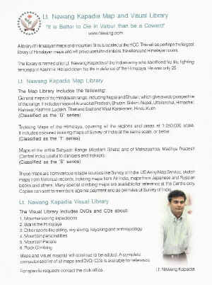
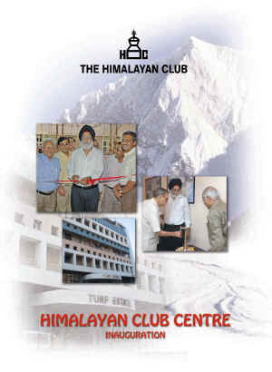
Invitation for the inaugural ceremony of the Lt. Nawang Kapadia Map and Visual Library
By Harish Kapadia
May 6, 2006
He was just 5 years in age, when Nawang walked all the way to top of a lovely hill called Bhivpuri, near Matheran. On top of this hill was a small rock and I was fascinated to see him climbing that little steep rock standing on the top and waving his hands. This was the beginning of enjoyment of hills for Nawang. He joined me on many such trips in the local hills, the Western Ghats and later a few to the Himalaya. As he grew up, the environment in the house left no choice for Sonam and Nawang to be connected with everything about mountains and mountaineering. One of the things that they were introduced was to the technical aspects of mountains. Expeditions were planned by me in our house and we all friends got together looking at pictures, transparencies and many maps were spread out. They were so engrossed by these activities at home that it inculcated a habit in them to be aware of these things. Many times we have a talk and show at home. Most of my talks they remembered it picture by picture. In fact when there was a group of novices, I may try to skip describing few pictures in greater detail to expedite the talk. There one of the children would always say, “Oh! You missed out on this picture” and I would have to revert back and explain everything in detail.
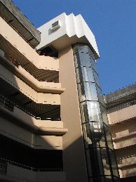
HCC Building
 In 1984 we organized a major camp/expedition to the Ruinsara valley. Nawang, Sonam and several children from our friends accompanied us. Once at the base camp, in front of Kalanag Peak, Jagdish Nanavati, a Guru to all of us spread out maps and we all including these young children bend upon these sheets and picked up compass and starting calculating heights and all the basics of map reading. This was in the days when unfortunately in India, maps were still restricted and many did not know how to use a map. Thus Nawang developed an interest in maps and the visual aspects of mountains very early in life. Later with his training in the army, maps became part of his life and the map culture as such was thoroughly ingrained in him.
The same situation of lack of availability of good maps for mountaineers continues even till today – well almost. When the Himalayan Club moved into its own premises, the “Himalayan Club Centre” (HCC) in a central locality in Mumbai, I decided to put all my maps for use of all members, non-members and mountaineers worldwide to make a reference or obtain copies as we can send them as per rules. This library of maps now contains more that 300 maps and some of our good friends have donated almost equal number of more maps to be included in this library.
Along with this, I also decided to make many visual films with me available at the Himalayan Club Centre premises for other people to enjoy and learn from it. Thus an initial 50 CD and DVD library of adventure and mountaineering films was also started at the Centre. These maps and visual library are named as “Lt. Nawang Kapadia Map and Visual Libraries” and was inaugurated by Dr. M. S. Gill, the President of the Himalayan Club on 6th May 2006. These maps can be referred to at the Himalayan Club Centre and there is equipment to enjoy the films, sitting in that office. Any person (not only a Himalayan Club member) can request for a particular map which will be sent to him at cost. It is hoped that many will take advantage of this facility at perhaps the largest Himalayan library anywhere and particularly for Indians this will change the way they look at mountains and operate in mountains.
Inaugurating the library, Dr. Gill said in his speech,
“The Himalayan Club Centre will house the ‘Lt Nawang Kapadia Map and Visual Library’. It contains more than 300 maps of the Himalaya covering almost all areas at different scales, possibly largest such library of Himalayan maps anywhere in the world. (Another 400 maps will be added to this collection soon). These maps are available for reference and copies can be sent to members anywhere in the world (subject to the regulations of the Survey of India). More than 40 DVD and CDs with films related to aspects of mountains and mountaineering are also part of this library. One can view these in the Centre where all facilities are provided. All details and catalogues of the library will be posted on the website and also with major Clubs and associations in the world so that a search can be made easily.
For this unique collection, the Club is indebted to Harish Kapadia and his wife Geeta who have turned grief of loss of their brave son into a wonderful memorial with this donation. Harish, a well-known explorer and recipient of many National and International honours, has created a fund of knowledge by his books on the Himalaya, which are my favourite readings. Now with this vast library of maps and visuals he has added another aspect of reference for the mountaineering community with a lasting impact. My special appreciation for these brave parents whose son loved the Himalaya and sacrificed his life in its defence.
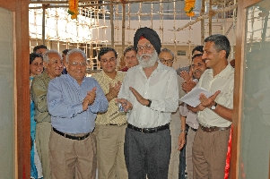
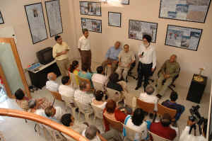
Inauguration by Dr. Gill and Inaugural speech
I hope all members of the Club will take advantage of the facilities offered at the Himalayan Club Centre. All visiting mountain enthusiasts or students are most welcome to visit the Centre and learn about the Himalaya and the Club. With this new centre, the Club has entered a new phase in its history, which will allow it to flourish for decades. Like all members, I am proud to be part of this great moment.”
The full details of the Lt. Nawang Kapadia Map and Visual Library are as under :
A library of Himalayan maps and mountain films is located at the HCC. This will be perhaps the largest library of Himalayan maps and will prove useful to climbers, travelers and Himalayan lovers.
The library is named after Lt. Nawang Kapadia of the Indian army who sacrificed his life, fighting terrorists in Kashmir. He laid down his life in defence of the Himalaya. He was only 25.
Lt. Nawang Kapadia Map Library
The Map Library includes the following;
1. General maps of the Himalayan range, including Nepal and Bhutan, which give a wide perspective of the range. It includes maps of Arunachal Pradesh, Bhutan Sikkim, Nepal, Uttaranchal, Himachal, Kishtwar, Kashmir, Ladakh, Tibet and East and West Karakoram, Hindu Kush. ( These are classified as the G series)
2. Trekking Maps of the Himalaya, covering all the regions and areas at 1:250,000 scale. It includes coloured trekking maps of Survey of India 1: 250,000 scale, or better. (Classified as T series)
3. Maps of the entire Sahyadri Range (Western Ghat) and of Maharashtra, Madhya Pradesh (Central India) useful to climbers and trekkers. round (Classified as S series)
These maps are from various reliable sources like Survey of India, US Army Map Service, sketch maps from historical records, trekking maps from Air India, Maps from Japanese and Russian books and others. Few special maps are available for reference at Centre only. Copies can sent to members against payment and as per rules of Survey of India.
Lt. Nawang Kapadia Visual Library
The Visual Library includes DVDs and CDs about:
1. Mountaineering expeditions 2. War in the Himalaya 3. Other sports like skiing, sky-diving, kayaking and anthropology. 4. Mountain personalities 5. Mountain People 6. Rock Climbing
Maps and visual material will continue to be added. A complete computerised list all maps and DVD/ CDs is available for reference.
Please feel free to write and use these facilities wherever you are. Contact HCC at
Lt Nawang Kapadia Visual Library
Himalayan Club Centre
314, Turf Estate,
Shakti Mills Lane, Off Dr. E. Moses Road,
Mahalaxmi West,
Mumbai 400 011 (India)
Phone (91-22) 2491 2829
E mail: hc@himalayanclub.com
Web: www.himalayanclub.com


